Singalila Round Trek:

Singalila Round Trek:
Duration 15 Days / 14 Nights
Location Uttarey West Sikkim
Group Size 2-12 People
Difficulty Hard
Starting From ₹48,000 Per person

The Singalila Round Trek is one of the longest treks in Sikkim. It starts in Uttarey, a small village on the Nepal border. It ends 15 days later in Yuksom, the old capital of Sikkim. In between, you walk the full Singalila Ridge, cross two high passes, and join the famous Goechala trail.

This trek covers a lot of ground. You start in warm forest below 2,000 metres. You finish at Goechala Viewpoint 1, at 4,600 metres, with Kanchenjunga rising right in front of you. Along the way, you pass through the Barsey Rhododendron Sanctuary. You also skirt the edge of Khangchendzonga National Park, home to the snow leopard.

This is not a trek for beginners. You cover about 150 kilometres on foot. You climb from 1,950 metres to 4,600 metres over 15 days. But if you want real wilderness, away from the busy Goechala trailhead near Yuksom, the Singalila Round Trek is hard to beat.

What Makes This Trek Different

Most Goechala trekkers start and end in Yuksom. That trip takes 8 to 10 days. The Singalila Round Trek adds a full extra week. You approach from Uttarey instead, on a quieter path along the Singalila Ridge. You then join the main Goechala trail at Dzongri. This gives you two treks in one: a quiet border route, followed by the classic Goechala finale.

On Day 3, a short side trip takes you to Phoktey Dara. From here, on a clear day, you can see four of the five highest mountains on Earth at once: Everest, Lhotse, Makalu, and Kanchenjunga. Few places in the world offer that view without a full mountaineering trip.

Best Time for the Singalila Round Trek

Sikkim’s monsoon runs from mid-June to mid-September. Avoid the trail in this window. Landslides, leeches, and low visibility make it unsafe. That leaves two good seasons for this trek.

Spring (March to May) is rhododendron season. Over 600 types of rhododendron bloom across Barsey and the lower ridge. The forest turns red, pink, and white. Days are mostly clear, with a few afternoon showers. Some snow may still sit on high passes like Danphebhir La.

Autumn (mid-September to November) gives the clearest views of the year. The monsoon washes the dust from the sky. Views from Phoktey Dara and Goechala Viewpoint 1 are at their sharpest. Nights turn cold, and frost is common. But the trails stay dry.

Either way, pack for freezing nights. Camps like Dhoor, Lampokhari, Lamuney, and Thangsing sit above 3,700 metres. Sub-zero nights are normal here, in both seasons.

See our guide to the best time to trek in Sikkim for how this compares to our other West Sikkim routes.

Permits You Will Need

Sikkim shares borders with Nepal, Tibet, and Bhutan. The government watches this zone closely.

Indian citizens do not need an Inner Line Permit for Sikkim. But you do need a Protected Area Permit (PAP) for this route, since it runs along the border and enters Khangchendzonga National Park. We arrange this through the Tourist Information Centre in Gangtok or Pelling. It needs sign-off from the Home Department, the Forest Department, and the Army. Bring a Voter ID, passport, or driving licence. PAN cards and Aadhaar cards are not accepted. Also bring a few passport-sized photos.

Foreign nationals need two permits: a Restricted Area Permit (RAP), free at entry points, and a PAP for the trekking zone. Foreign trekkers cannot go solo here. You need a group of two or more, plus a registered agency and a licensed guide. Citizens of China, Pakistan, and Afghanistan need extra clearance from Delhi. This takes more time, so plan ahead.

Zeal Adventures handles all permit paperwork. Just send us your ID and photos before the trek.

For the complete RAP/PAP process and required documents across Sikkim, see our comprehensive Sikkim permits guide.

How Hard Is the Singalila Round Trek?

We rate this trek Challenging. You need good fitness and some weeks of training before you go. Walk hills. Climb stairs. Run or cycle long distances. The trail is rarely flat. Expect steep climbs and hard descents over loose rock and roots, day after day, for close to two weeks.

Altitude is the other big factor. The route climbs to 4,600 metres. Acute Mountain Sickness is a real risk this high up. The plan includes rest days at Chewabhanjyang, plus buffer nights at Dzongri and Lamuney. This follows a simple rule: climb high, sleep low. Even so, this trek suits trekkers with some high-altitude experience far more than first-timers.

Meals on the trek are vegetarian, with eggs. Meat digests slowly at altitude and can make AMS worse. Expect rice, lentils, potatoes, and local vegetables. Non-vegetarian food is available in Yuksom, before or after the trek.

Trek Highlights

  • Four of the world’s five highest peaks from one spot at Phoktey Dara.
  • A real border trek, walking the ridge between India and Nepal for days.
  • Sunrise at Goechala Viewpoint 1 (4,600m), facing the east wall of Kanchenjunga.
  • Kanchenjunga, Pandim, and Kabru reflected in the still water of Samiti Lake.
  • A walk through the Barsey Rhododendron Sanctuary, one of Sikkim’s richest forests.
  • Two high passes in one day: Danphebhir La and Kag Bhir La, both above 4,500m.
  • A real chance of spotting Himalayan Blue Sheep, and rare Snow Leopard sightings.
  • A night in Yuksom, where Sikkim’s first king was crowned in 1641.
Day-by-Day Itinerary

1 Day

Arrival at Uttarey (1,950m)

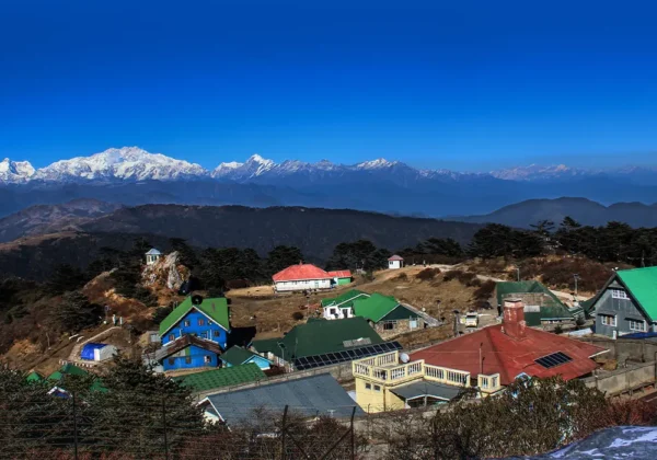
Your trip starts with a 6 to 7-hour drive from Bagdogra Airport or NJP railway station. It covers about 165 kilometres through the Teesta and Rangeet valleys. Uttarey sits right on the Sikkim-Nepal border. Limboo, Gurung, Sherpa, and Bhutia families live here. Spend the afternoon on gear checks and permit briefings. Visit the local monastery if there's time. Sleep early.

2 Day

Uttarey to Chewabhanjyang (3,145m), 15km

The trek starts with an easy climb through a small village. Then the trail turns steep, into the Barsey Rhododendron Sanctuary. Expect mossy oaks, thick bamboo, and damp green forest most of the day. The last two hours are a hard climb onto the Singalila Ridge. Chewabhanjyang sits right on the India-Nepal border, watched by army posts from both sides. Your permits get checked here. Rest well tonight and watch for signs of altitude sickness.

3 Day

Rest Day and Hike to Phoktey Dara (3,588m-3,850m), 5km round trip

A planned rest day, built around a pre-dawn hike to Phoktey Dara. This spot marks the meeting point of Sikkim, Nepal, and West Bengal. On a clear morning, you get a full circle view that includes four of the five highest mountains on Earth: Everest, Lhotse, Makalu, and Kanchenjunga. The "Sleeping Buddha" peak is also visible from here. Head back to Chewabhanjyang to rest and let your body adjust.

4 Day

Chewabhanjyang to Dhoor (3,749m-4,760m), 16km

Today follows the actual line between India and Nepal, crossing back and forth as you go. The trail runs along open hillsides strung with prayer flags near Major Dara. There's almost no one out here, just the odd stone hut used by yak herders. Far below, you can see cardamom farms. The thick rhododendron forest thins into open meadow. Camp at Dhoor sits in a sheltered dip, safe from the wind.

5 Day

Dhoor to Sikkim Meghu (3,905m-3,916m), 13km

A long ridge walk today, with small ups and downs that keep your overall height steady. The trail crosses small passes marked by Hindu shrines. You get wide, open views of Kanchenjunga, Kabru, and Talung all day. This rocky, exposed stretch is good ground for Himalayan Blue Sheep, often seen on the slopes above the trail. Camp sits near an old shepherd's settlement at Sikkim Meghu.

6 Day

Sikkim Meghu to Lampokhari (4,297m-4,323m), 11km

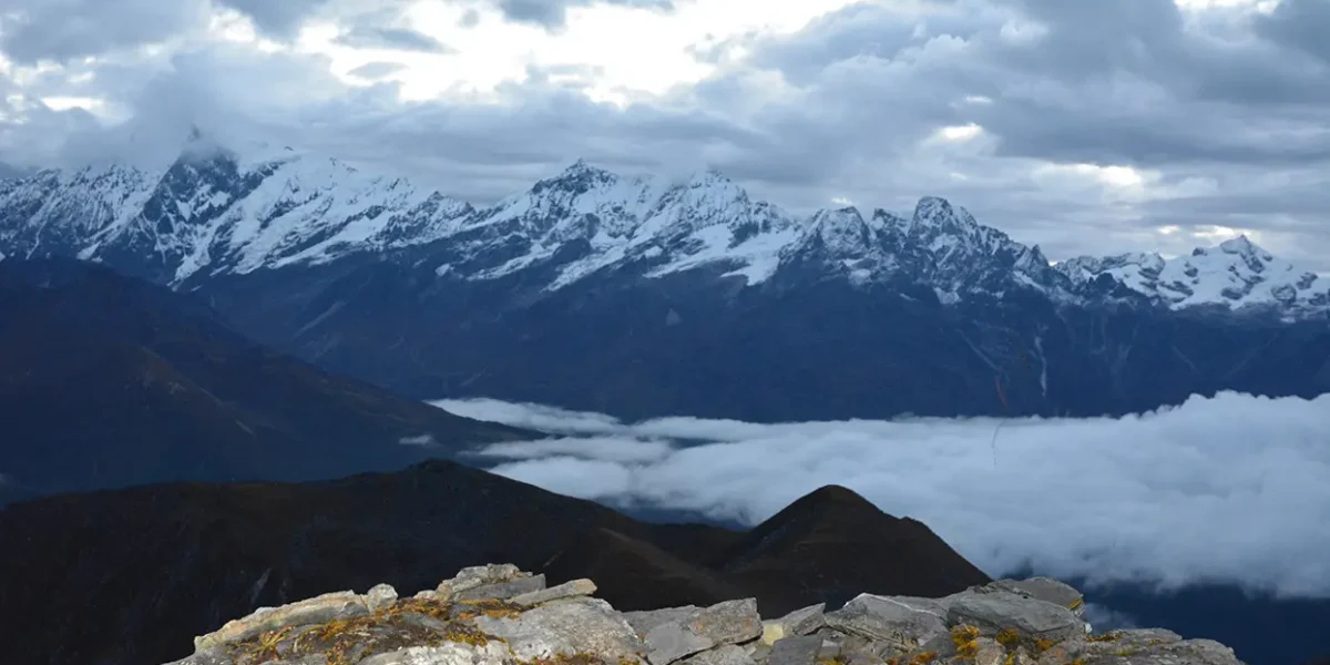
Plants thin out fast as you climb past 4,000 metres. An easy start through light woodland leads into a wide valley climb. Watch your footing near the top, where the trail turns to loose scree. Once you reach the top of the valley, Mount Pandim (6,691m) and the full Kabru range come into close view. Lampokhari is a bare, high camp. Sub-zero nights are the norm here.

7 Day

Lampokhari to Gomathang (3,796m), 10km

This is the toughest day on the western half of the trek, and one of the best. You cross two passes back to back. First, Danphebhir La (4,515m-4,530m), the Pass of the Pheasant, with views into Tibet and Bhutan. About an hour later comes Kag Bhir La (4,580m), the Pass of the Crow, with a full view of the Kanchenjunga range. After the second pass, a steep drop takes you down to the green Gomathang valley. Camp sits beside a clear mountain stream.

8 Day

Gomathang to Pangding (4,268m-4,317m), 15km

The day starts with an easy walk beside the river. Then the trail enters a sweet-smelling forest of silver fir and rhododendron. The calm doesn't last long. A steady climb through high meadows brings you to Pangding. This camp gives you a clear view of nearly every major peak on the trek.

9 Day

Pangding to Dzongri (3,950m-4,170m), 10km

Today you leave the quiet Singalila Ridge behind. You drop into the Rolepthang valley to cross the Tikep Chhu and Rathong Chhu rivers. Pine forest and big boulders reappear on the other side, a good spot to rest. From there, a final climb brings you to Dzongri. This busy meadow is the main junction for every trekking route in West Sikkim. Here, your quiet border trek joins the well-known Goechala trail.

10 Day

Dzongri Top Sunrise and Descent to Kokchurong/Thangsing (3,658m-3,800m), 10km

Wake up before dawn for a 45-minute headlamp climb to Dzongri Top (4,170m). This spot is known for its sunrise, when Kanchenjunga, Kabru, and Pandim glow pink, blue, and gold. Back at camp for breakfast, the trail then leads through soft meadows before a steep, hour-long drop through forest to Kokchurong, right by the Prek Chu river. Some groups camp here. Others push on to the open valley at Thangsing, below Mount Pandim.

11 Day

Thangsing to Lamuney (3,950m-4,150m), 3.5km

The shortest, easiest day of the trip. It's a rest day before the big push ahead. A flat, scenic walk through old glacier ground and low shrubs gets you to Lamuney in under two hours. The east face of Kanchenjunga looms closer with every step. Lamuney sits in a deep, icy trough near the glaciers, making it the coldest camp on the route. Rest all afternoon and get ready for an early start.

12 Day

Goechala Viewpoint 1 (4,600m) and Return to Kokchurong (3,600m), 15km round trip

This is the day the whole trek builds toward. Wake up at 2:00 AM. You climb slowly, in the dark and the cold. The trail passes the sacred Samiti Lake (4,200m), crosses the sandy flat of Zemathang, and climbs the final slope to Goechala Viewpoint 1. Since April 2017, this is as far as trekkers are allowed to go. The ground beyond is now a protected zone for Snow Leopards and Blue Sheep. Even so, you get one of the closest views of Kanchenjunga's east face in the whole Himalaya, lit up as the sun rises. On the way down, Samiti Lake often shows a perfect mirror of the peaks above it. After a quick lunch at Lamuney, you carry on down to Kokchurong.

13 Day

Kokchurong to Tshoka (2,950m), 12km

A direct path from Kokchurong to Phedang (3,550m), cutting across the hillside through thick forest. Little light gets through the trees here. From Phedang, the trail drops steadily into Tshoka, a small village of Tibetan refugees. It has private wooden huts and your first phone signal in days.

14 Day

Tshoka to Yuksom (1,750m), 16km

Your last day on foot runs through warm forest full of ferns, moss, and wild orchids. You cross several rope bridges over the Prek Chu, Paha Khola, and Tshuchey rivers. The air gets warmer as you pass through Bakhim and Sachen, and the trail flattens out into Yuksom. This old town gets its name from the "meeting point of three lamas." It was the site of Sikkim's first coronation in 1641. Spend the evening at Dubdi Monastery, and rest.

15 Day

Departure to Bagdogra/NJP

An early drive of about 150 to 165 kilometres back to Siliguri, Bagdogra Airport, or NJP. This takes around 6 to 7 hours and connects you to your onward journey home.

What's Included

  • All permits and forest camping fees, including PAP paperwork.
  • Return transport between NJP/Bagdogra and Uttarey/Yuksom.
  • 2 nights hotel or homestay in Yuksom, before and after the trek, with meals.
  • All meals on the trek: vegetarian, breakfast to dinner, Day 2 to Day 14.
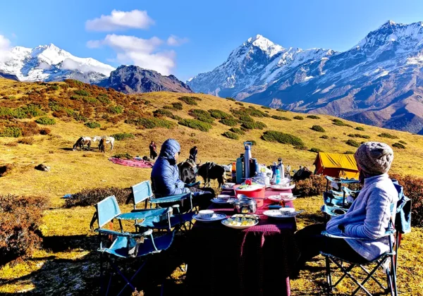
  • Camping gear: sleeping tents, dining tent, kitchen tent, toilet tent, sleeping bags.
  • A licensed trek leader, cook, kitchen staff, and porter or mule support.
  • Safety gear: first-aid kit, oxygen cylinder, and stretcher on call.
  • Up to 10kg of free luggage carried by porter or mule per person.

What's Excluded

  • Travel insurance (we can arrange this on request).
  • Meals during transport days (Day 1 and Day 15).
  • Alcohol, soft drinks, and bottled water.
  • Personal gear (boots, jackets, backpack, and the like).
  • Costs from landslides, road closures, or bad weather.
  • Personal spends, tips for staff, laundry, and phone charges.
  • Extra baggage past 10kg (₹250 per day, per bag).

Tour Location

No reviews yet. Be the first to share your experience after travelling with us!

Share Your Experience

Completed this tour or trek with us? We would love to hear about your journey.

Not shown publicly

Rate Your Experience

Overall Experience *
Service Quality
Guide & Team
Value for Money

Frequently Asked Questions

The standard route takes 15 days from Uttarey to Yuksom. This includes one rest day and two travel days.

We rate it Challenging. You need good fitness, past trekking experience, and ideally some time at altitude before you try this one. It's not a trek for beginners.

Goechala Viewpoint 1, at 4,600 metres. This is as far as civilians can go. The route beyond has been closed since April 2017, to protect Snow Leopard and Blue Sheep habitat.

Yes. From Phoktey Dara on Day 3, you can see Everest, Lhotse, Makalu, and Kanchenjunga together on a clear day. Few spots in the world offer this exact view.

Indian citizens need a Protected Area Permit (PAP), which we arrange in advance. Foreign nationals need both a Restricted Area Permit (RAP) and a PAP, and must travel in a group of two or more with a registered agency.

March to May for rhododendron blooms, or mid-September to November for the clearest views. Avoid mid-June to mid-September, when the monsoon makes the trails unsafe.

Yes. Meals on the trek are vegetarian, with eggs. This is easier to digest at altitude. Non-vegetarian food is available in Yuksom, before or after the trek.

We run this trek for groups of 2 to 12 people. Smaller private groups are also possible, though the per-person cost will be higher.

Given the altitude and distance here, we recommend at least one past high-altitude trek, at 3,500 metres or above, before you try this route.

A 60-litre backpack, waterproof trekking boots, and warm layers for freezing nights. Skip heavy fabric like denim, since it stays wet too long. Also pack a small first-aid kit with pain relief, digestive aids, and antiseptic cream.